FORTAG and Frog Pond. 1: What is Frog Pond?
(See also: Main FORTAG Frog Pond Page)
Click on map to enlarge:
The area known as "Frog Pond" centers on the Frog Pond Wetland Preserve, a 16.82 parcel owned by the Monterey Peninsula Regional Park District (MPRPD) to the west of General Jim Moore Boulevard (GJMB) and north of Highway 218 (Canyon Del Rey Boulevard). The parcel was named Frog Pond Natural Area after MPRPD acquired it in 1977. The current name "Frog Pond Wetland Preserve" arose in the mid-1990s around the time a weir and berms were constructed to enhance the wetland.
The pond itself is a seasonal pond in the middle of FPWP, enhanced in its present configuration as a result of bobcat excavation and impoundment in the mid-1990s.
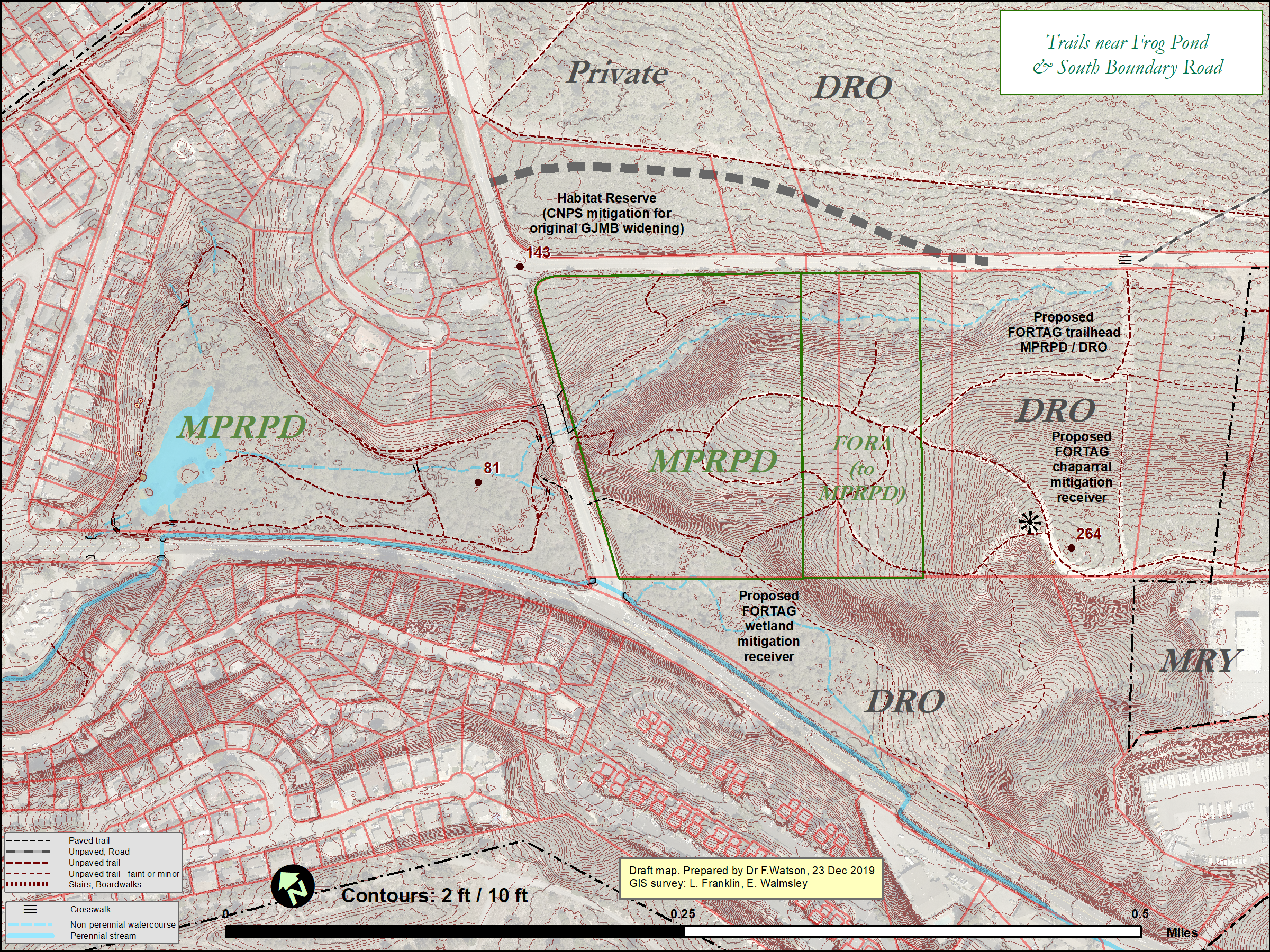
The larger "Frog Pond" area also includes 20.17 acres in two parcels to the east of GJMB. These lie within the former Fort Ord are sometimes referred to as "Frog Pond East". In the nomenclature of Fort Ord reuse, they are known as the Natural Area Expansion (NAE) - a reference to them being intended as an expansion of the Frog Pond Natural Area.
The largest of the two eastern parcels comprises 13.27 acres and has been owned by MPRPD since mid-2009. To the east of this lies a 6.90 acre parcel that was transferred to MPRPD by FORA in 2020.
(There is substantial disagreement between maps in the deeds, county parcel
GIS data, and Army parcel GIS data in this area. The acreages above are taken from the deeds, which fairly closely match the 1999 settlement agreement.)
In total, the Frog Pond parcel network currently comprises 36.99 acres. The eastern parcels total 20.17 acres. The eastern parcels are 20% larger than the western parcel. Their addition more than doubles the area of property owned by MPRPD at Frog Pond.
A diverse range of habitats exist at Frog Pond, including:
-
- Western parcel
- Palustrine - the pond itself
- Riparian & wetland - extensive dense willow forest surrounding the pond
- Oak woodland - coast live oak trees and annual grasses
- Non-native trees - numerous tall acacia trees and about two English hollies
- Semi-native trees - coast redwoods planted in the northwest corner of the western parcel
- Ruderal - non-native vegetation patches including iceplant, ivy, thistle, and prickly pear
- Eastern parcel
- Oak woodland
- Maritime chaparral
- Bishop pine
- Herbaceous wetland
- Western parcel
- Existing trails and access points at Frog Pond
In the western parcel, there is a main loop trail that runs completely around the greater pond area, a trail that cuts across the middle of the loop, and a dead-end trail that heads west from the cut-across trail. There is an observation deck on the western shore of the pond, and three benches and a plaque along the western section of the main loop trail. There are seven small foot bridges.
In the eastern parcels, there is system of ad hoc former Army trails generally traversing a main east-west ridge. Connections can be made over steep terrain east-west between GJMB and Rancho Saucito Lane in Ryan Ranch, and between GJMB and South Boundary Road (SBR) through a small parcel owned by the City of Del Rey Oaks.
The main access point to Frog Pond is on the south side of the western parcel, on the shoulder of Highway 218. This access point not owned by MPRPD. It lies within the CalTrans right of way (ROW), including space for about five cars, a flight of steps, trash cans, and about 90 feet of the main loop trail.
The western parcel can also be accessed from the east, off GJMB, via a 4-ft concrete sidewalk along GJMB that veers down westward to meet the main loop trail.
The eastern parcels can be accessed from GJMB via a 4-ft sidewalk along GJMB, from South Boundary Road via some City-owned land to the east of the MPRPD land, and from the "Dust Trail" accessible from Rancho Saucito Lane about a mile to the east. None of the access to the eastern parcels experiences any substantial management. Instead, it occurs as informal ad hoc re-use of trails in former Army land.
None of the access points or trails are wheelchair accessible. All of the trails are uneven foot trails traversing uneven terrain.
Next: History of Frog Pond