FORTAG and Frog Pond. 3: FORTAG details
(See also: Main FORTAG Frog Pond Page)
(Note: This page is an unofficial description of FORTAG's goals at Frog Pond - provided by Fred Watson & Scot Waltz, volunteers and co-founders of the FORTAG proposal.)
- Status quo in the Frog Pond area, as is relevant to FORTAG
- None of the Frog Pond area is accessible to wheelchairs
- No safe parking access to Frog Pond
- Wildlife and hydrologic connectivity between western and eastern parcels impeded by earthen fill beneath GJMB
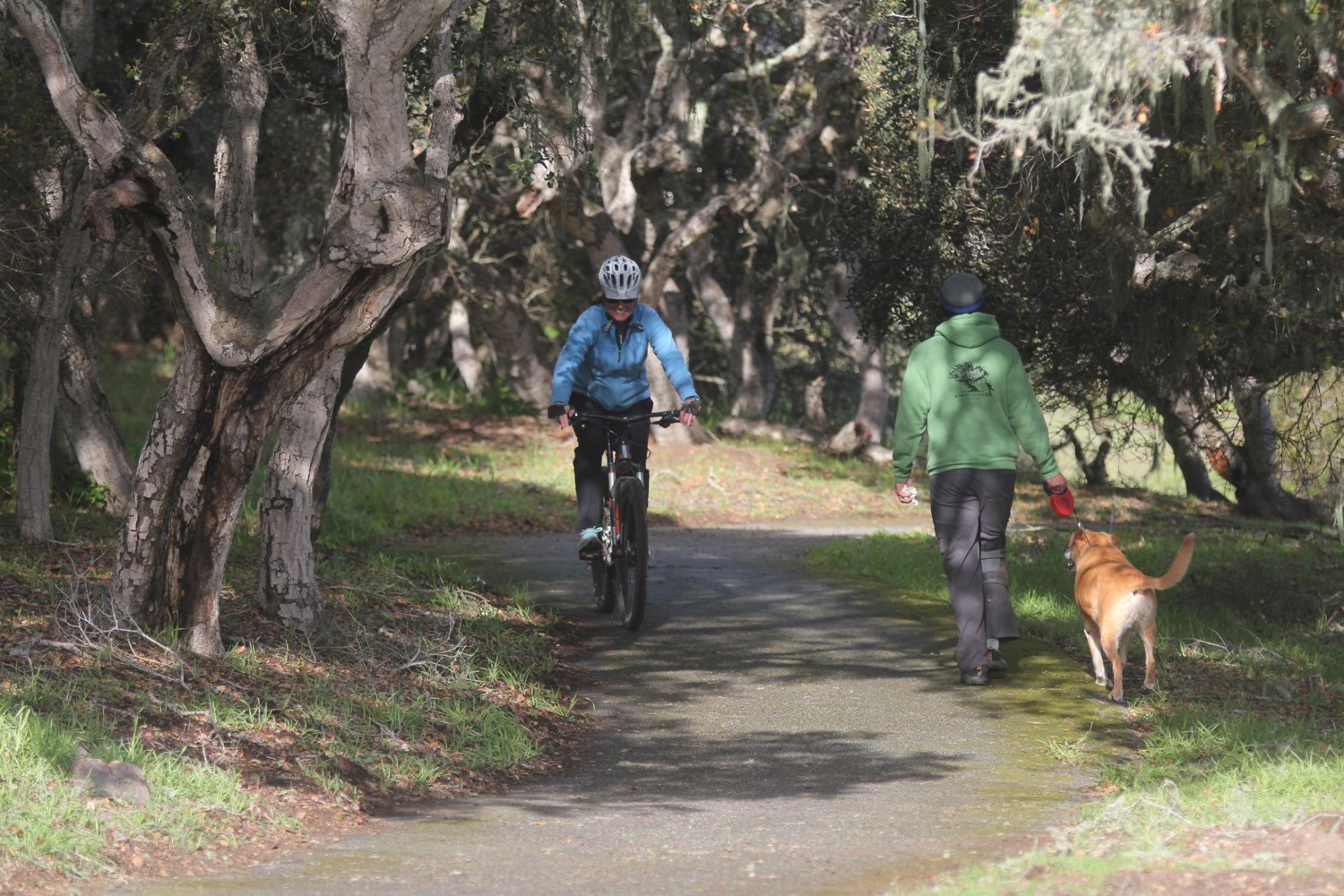
- Biking along Canyon Del Rey is dangerous - for anyone connecting between coastal areas and either Fort Ord, Ryan Ranch, or Stonecreek. Families cannot bike along Canyon Del Rey
- Non-native plants have substantially invaded large portions of the preserve, including acacia trees, iceplant, ivy, prickly pear, italian thistle, and English holly
- Very limited public access to the eastern parcels
- No safe non-vehicular access between Canyon Del Rey, Fort Ord National Monument, Ryan Ranch, and the Del Rey Oaks portion of the former Fort Ord
- Key aspects of the FORTAG vision in the Frog Pond area
- Safe, accessible, pleasant connections between people and open spaces
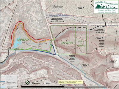
- Double the useable area of the Frog Pond public natural areas by removing the earthen fill separating the western and eastern portions, restoring the original valley topography, allowing safe and convenient access to the eastern portion. Realize long-term Park District goals to create a pedestrian connection between the western and eastern Frog Pond parcels.
- Facilitate long-term Park District goal to have a trailhead at the eastern edge of the easternmost Frog Pond parcel
- Restore wildlife & hydrologic connection between Frog Pond Wetland Preserve and the former Fort Ord
- Remove non-native plants and restore native habitat, particularly in the northwestern portion of the western parcel
- Augment the total area of contiguous protected land in the Frog Pond area with habitat mitigation acquisitions from City of DRO in land zoned for development but with severe practical development limitations due to wetness and steepness.
- The main thrust of what FORTAG proposes in the Frog Pond area
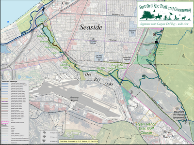
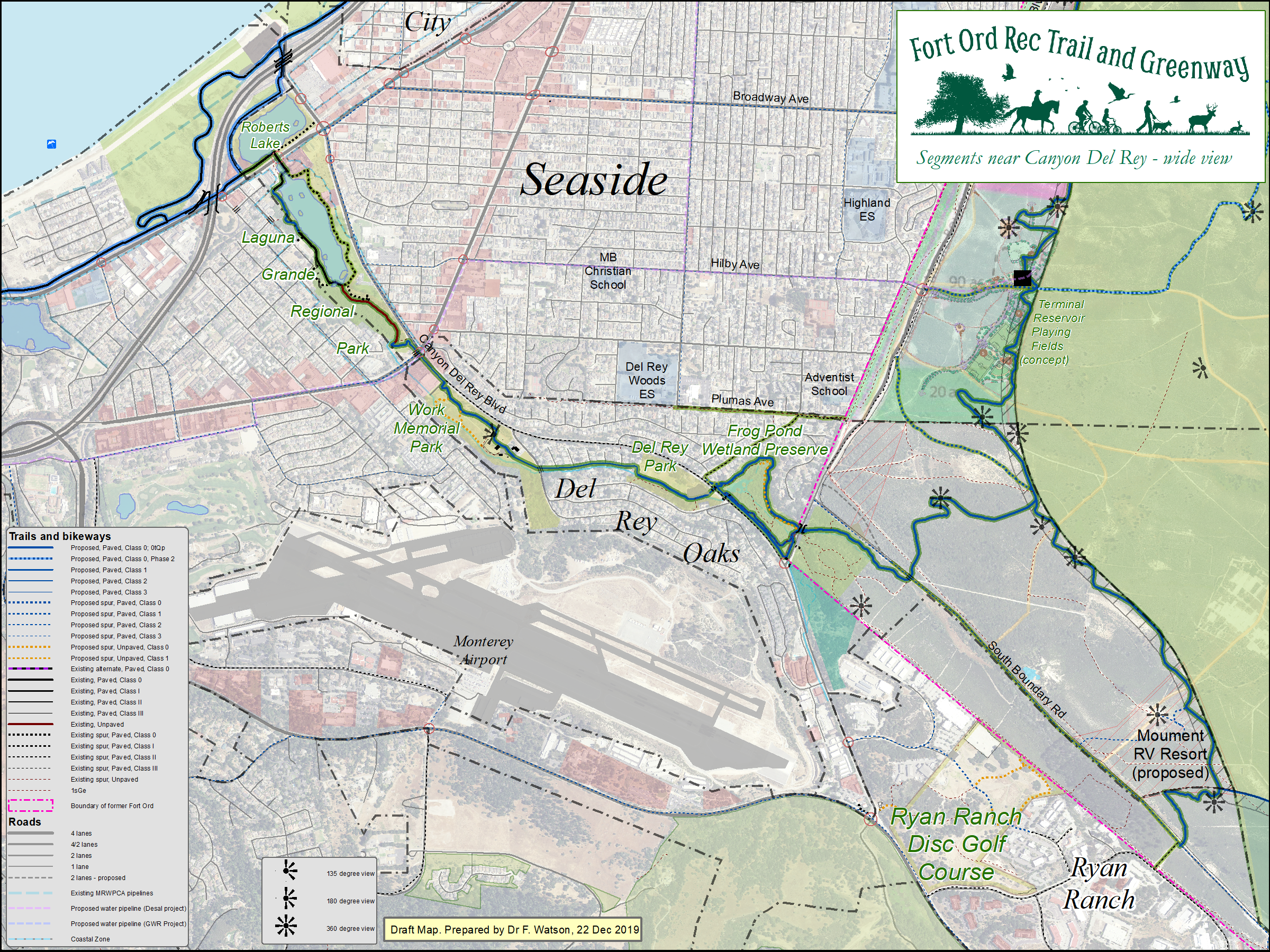
- Connect by safe, accessible, pleasant non-vehicular means all of the major open spaces in Canyon Del Rey: Monterey State Beach, Roberts Lake, Laguna Grande, Work Memorial Park, Del Rey Park, Frog Pond - on both sides of GJMB - and the Fort Ord National Monument.
- Remove the GJMB fill and restore the natural topographic connection between the western and eastern parcels, including connectivity for wildlife, hydrology, and public access.
- Create a safe, accessible, pleasant 8-ft paved multi-purpose trail connection between Del Rey Park and South Boundary Road - connecting to and either through or beside the western Frog Pond parcel, and connecting through the eastern Frog Pond parcels.
- Underpasses at Hwy 218 and GJMB
- Better access to the eastern Frog Pond parcels that more than double the area of MPRPD-owned property.
- Increase area of protected land through mitigation acquisitions, including: the wetland portion of DRO's development parcel south of the eastern MPRPD parcels, and chaparral portions of DRO's development parcels east of the eastern MPRPD parcels.
- Connect by safe, accessible, pleasant non-vehicular means all of the major open spaces in Canyon Del Rey: Monterey State Beach, Roberts Lake, Laguna Grande, Work Memorial Park, Del Rey Park, Frog Pond - on both sides of GJMB - and the Fort Ord National Monument.
- What could FORTAG look like at Frog Pond?
Eight feet wide. Either paved with "GraniteCrete" or a boardwalk. Traversible by wheelchairs. Carefully threaded between the trees.
This trail was constructed eight feet wide. Grass and leaves have encroached from the sides, so it now looks more like seven feet.

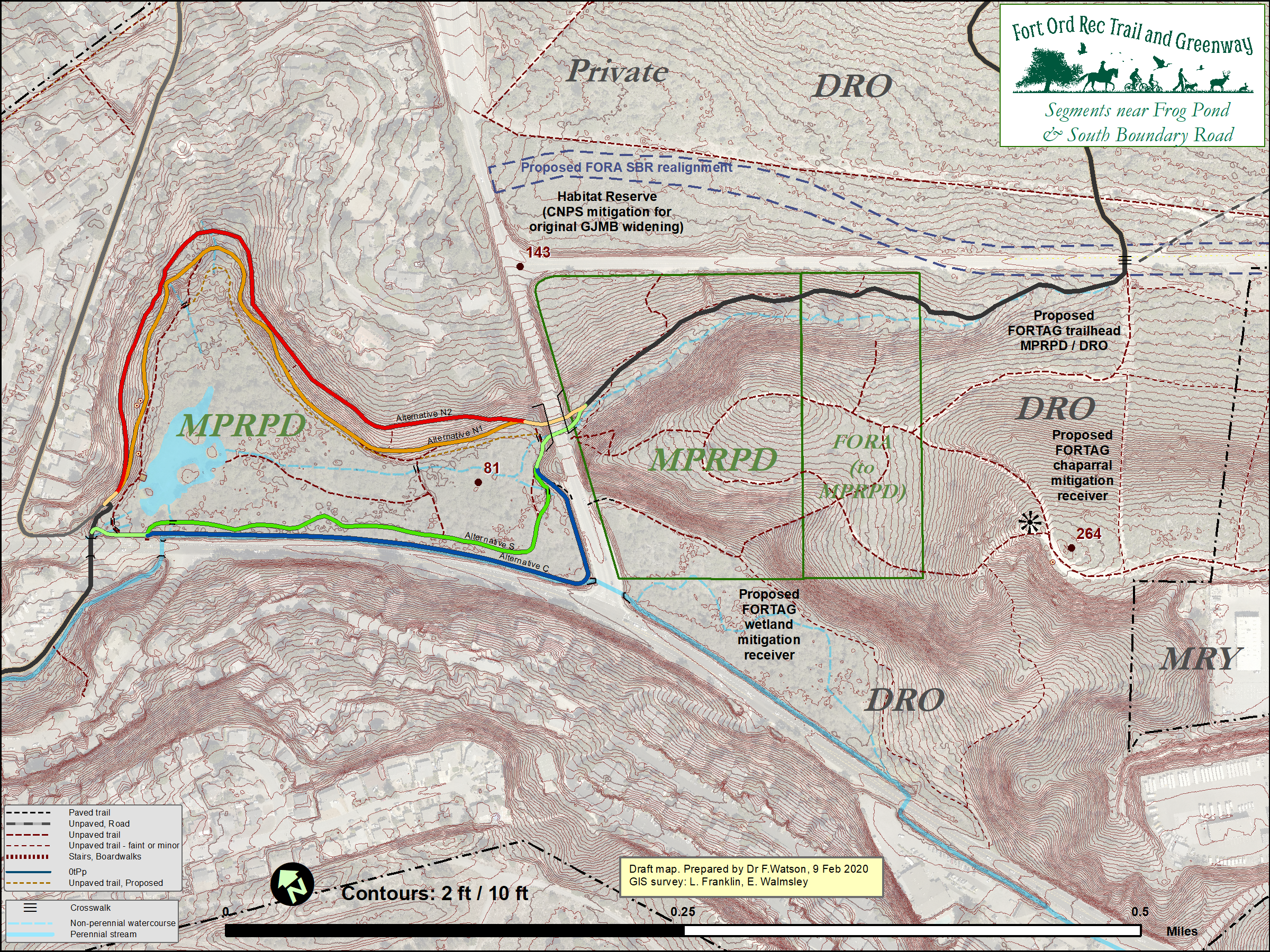
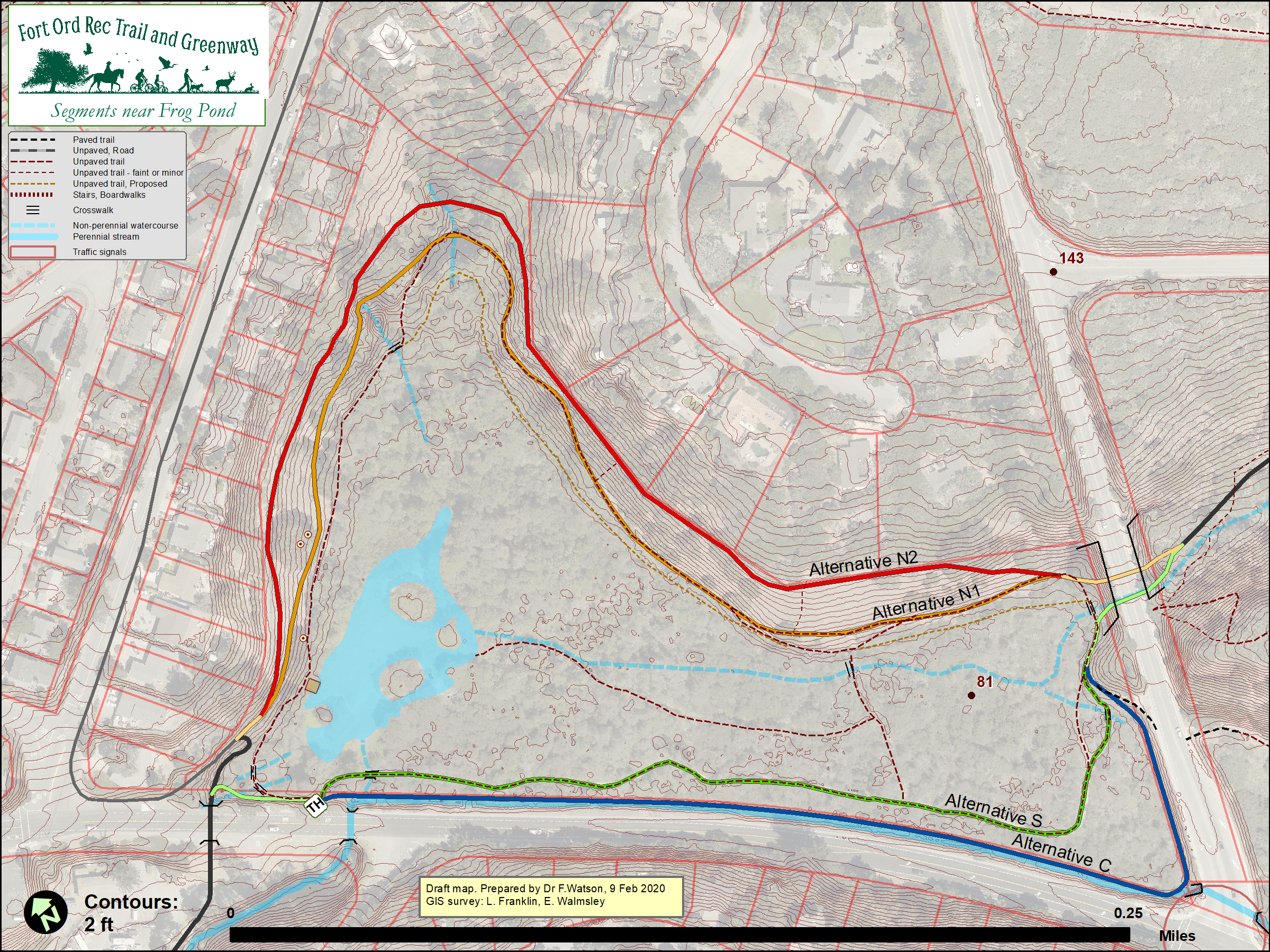
- FORTAG options being considered at Frog Pond. Three options are shown on these maps. The idea is that only one of these would be constructed.
Wider-area map:
 0
0
Western parcel map:

- Option "N" - Through the northern portion of FPWP. On eastern side, construct new 8-ft GC trail uphill from existing foot trail. On northern side, upgrade existing trail to 8-ft GC, and move foot trail down hill - in places re-occupying the route of the old "
Tanglewood Trail" described in the 1982 Interpretive Guide. Option "N" results in a bike-free foot trail around the entire pond property.
Option N1
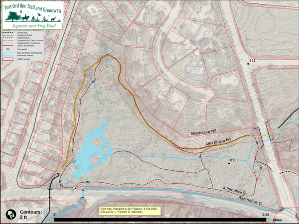
Option N2

- Option "S" - Through the southern portion of FPWP. Upgrade existing trail from decomposed granite ("DG") to 8-ft wide GraniteCrete (GC) - i.e. paved using natural materials, and permeable.
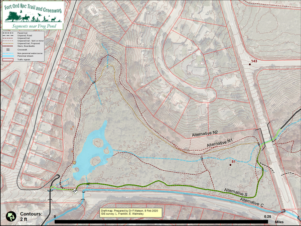
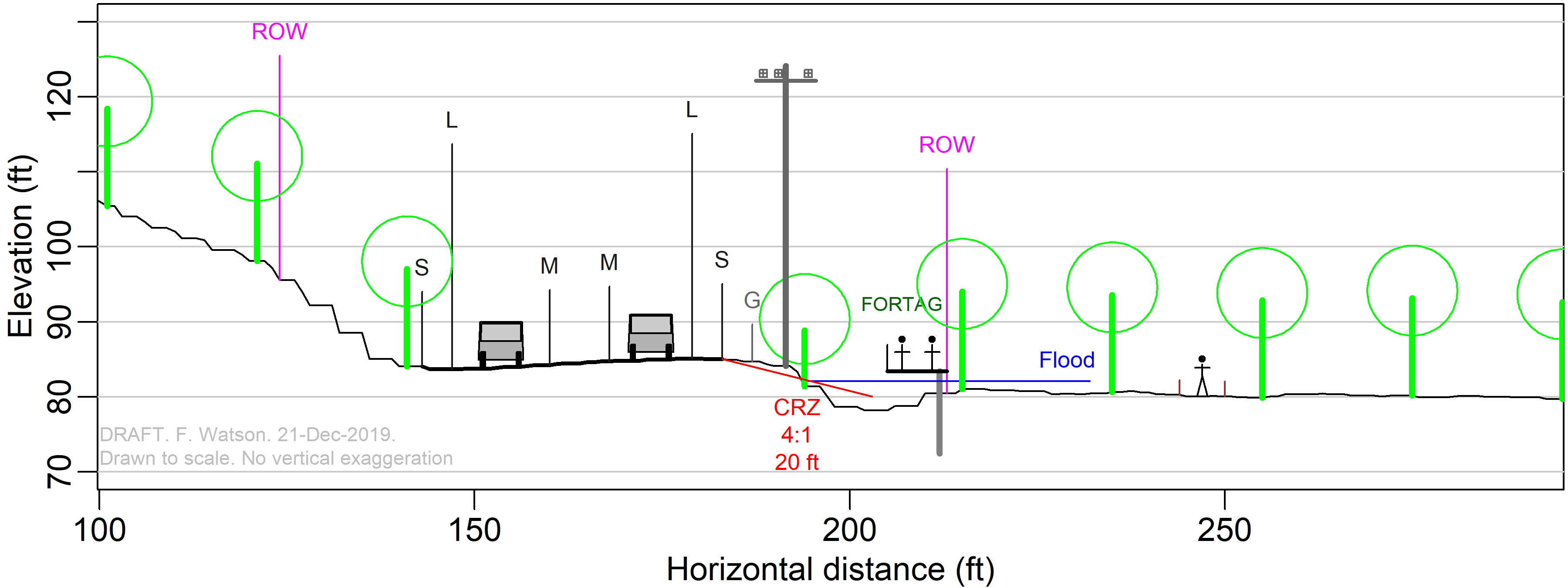
- Option "C" - Constuct a boardwalk over the creek beside the highway, generally outside FPWP and inside the CalTrans right-of-way.
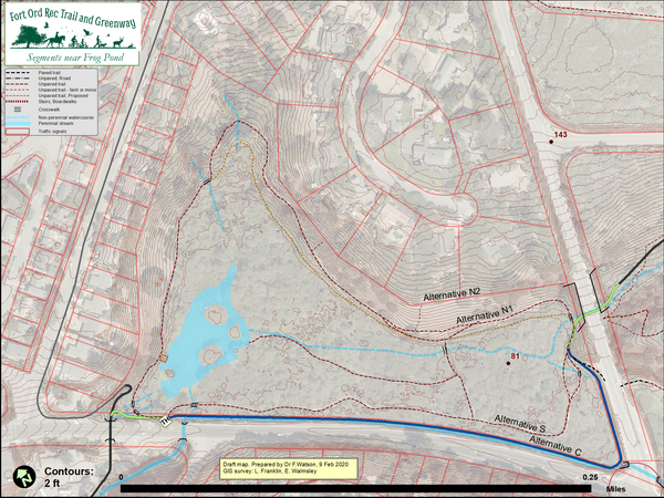
Here's one idea for what Option C could look like.
- Option "N" - Through the northern portion of FPWP. On eastern side, construct new 8-ft GC trail uphill from existing foot trail. On northern side, upgrade existing trail to 8-ft GC, and move foot trail down hill - in places re-occupying the route of the old "
Tanglewood Trail" described in the 1982 Interpretive Guide. Option "N" results in a bike-free foot trail around the entire pond property.
- Where do the options stand administratively?
- The FORTAG DEIR looked at Options S and N.
Option N is called "Alternative 4" in the DEIR.
Option N was split into two variants, N1 & N2, in Feb 2020. - Option C arose from comments made before and after the DEIR public review period. It was not included in the DEIR. Its future inclusion is being considered.
- The FORTAG DEIR looked at Options S and N.
- Some pros and cons of the options being considered

- Option S
- Bikes could be disruptive to wildlife - migratory birds, amphibians, etc.
- Bikes could be disruptive people seeking the slow, intimate pace that Frog Pond currently offers
- Options N1 & N2
- Less disruptive to wildlife because it would traverese the drier upland (oak woodland) habitat, further away from the wetland and riparian habitat (willows)
- Less disruprive to foot-trail users because employs separate paved and non-paved routes, and retains bike-free foot trail around the entire pond property
- Visual & fire-risk impacts perceived by neighboring homeowners along Carlton Drive
- Overall length of trails in preserve is larger than status quo
- Probably the environmentally superior alternative from a CEQA standpoint
- Option C
- More expensive to construct. Requires an engineered structure with long beams, and piles driven into the ground in areas that are difficult to access.
- Involves uncertain permitting process with CalTrans - for construction in the CalTrans right-of-way
- Involves uncertain permitting process with Army Corps of Engineers and California Department of Fish and Wildlife in relation to potential for streambed alteration, aquatic habitat, and ensuring no impediment to the passage of flood flows
- Travel is closer to highway and therefore less pleasant
- Option S
- Which option do the FORTAG founders prefer?
We have no preference between options N1, N2, S, and C - as long as we create a safe, accessible, pleasant trail and greenway connections to and either through or beside the western parcel, and then through the eastern parcels up to South Boundary Road and beyond toward the Fort Ord National Monument.
We have a strong preference against avoiding the Frog Pond area altogether - e.g. by bypassing it via Plumas, Carlton, and/or Mescal - because this would not achieve the fundamental FORTAG vision of safe, pleasant, and accessible connections to our public open spaces.


Back to: FORTAG & Frog Pond Main Page